Our Trip in Numbers:
7,386 total miles driven
142 hours drive time
29 bears seen (24 black
bears, 5 grizzly bears)
2 flat tires (one at
the beginning and one on the Dalton Highway)
0 rock chips
(surprisingly)
8 border crossings
1 major (250+ miles)
detour
20 nights in a tent
4 nights in a cabin
0 nights in a motel/hotel
If you want to know more details, read on! If not, feel free to scroll through and look at the pictures.
Alaska is a big state...here are just a couple pictures for comparison:
Monday, June 19: 7 hours drive time, 335 miles, 335 total
We were basically packed and ready to go Sunday night, but
Becky said the tire pressure gauge came on in the van. So Monday morning we took a slight detour to
Costco to have the tires inspected. It turned
out that we had a nail in one of the tires. We finally left Yakima at 12:45pm. After some bad traffic around Seattle and
Everett we finally picked up speed and made it to Bellingham. We also had to make a pit stop at the Value
Village in Bellingham so Becky could buy another pair of pants (she only packed
one pair). We finally made it to the
Canadian border around 6pm. We arrived
at Emory Creek Campground at 8pm. The
campground was right along the Fraser River.
The only issue is that there are train tracks on both sides of the river
that are heavily used. Trains came
through the canyon almost once an hour (in each direction) and took over ten
minutes to pass each time. This continued
nonstop throughout the night.
 |
| 1st dinner along the Fraser River |
Tuesday, June 20: 12.5 hours drive time, 640 miles, 975
miles total
We packed up and got on the road by 8am. We slowly made our way up through the steep-walled
Fraser River Canyon. At lunch we stopped
at 100 Mile House to see the giant skis.
Other than this, we didn't stop much today. Our main goal today was to get as much mileage
under our belts as possible. After 12.5 hours we finally
pulled in to Dawson Creek, B.C. and stayed at a very windy RV park.
Wednesday, June 21: 8.5 hours drive time, 477 miles, 1452
miles total
Thursday, June 22: 7 hours drive time, 400 miles, 1852 miles
total
After breakfast we decided to head back to the hot springs
for a morning soak before we hit the road.
We saw a moose foraging by the boardwalk on our way to the pools.
On the two hour drive to Watson Lake we saw
another 9 black bears roaming around by the road. In Watson Lake we took some time to walk
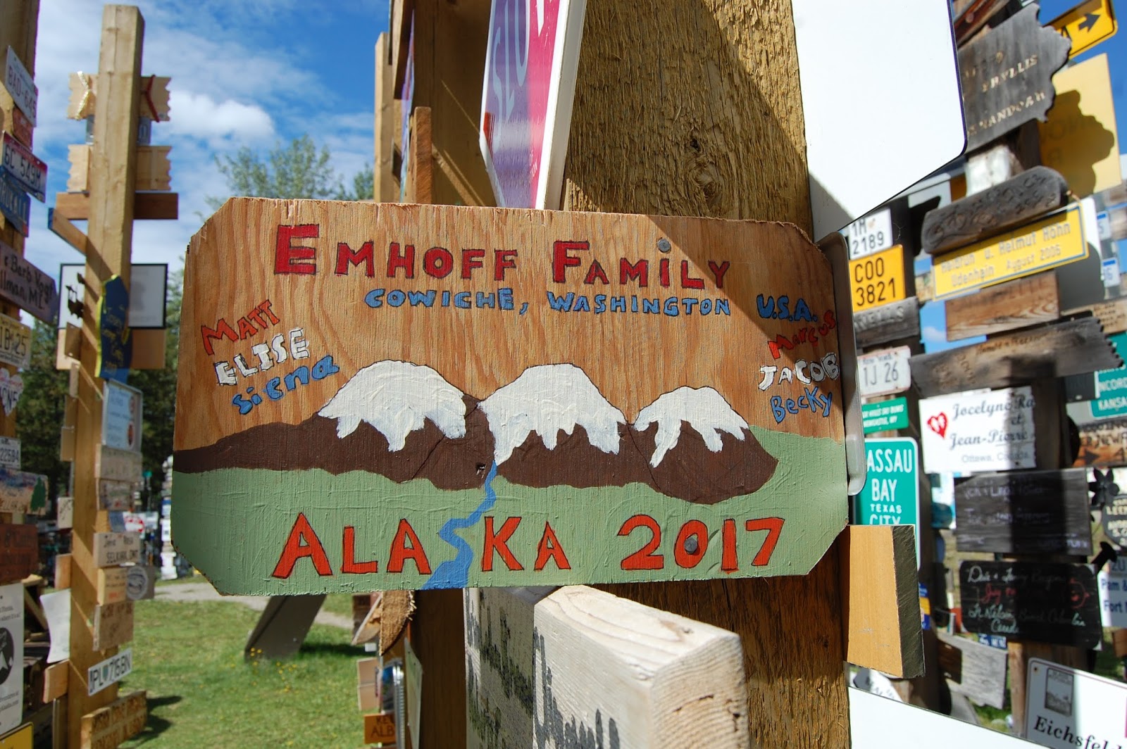
around the Signpost Forest. There are
currently over 83,000 signs there. It's
one of those places that you have to see it to believe it. We found a spot to hang our hand-painted Emhoff
Family sign.
 |
| Fox waiting for food at a rest area |
 |
| Signpost Forest, Watson Lake, Yukon Territory |
 |
| Adding our Emhoff Family sign to the forest |
After several more hours of
driving we finally pulled into a campground just outside of Whitehorse, Yukon
Territory. At the campground we met a
couple from Sydney, Australia that had shipped their motorcycles to Argentina
and had been riding their way north since November. It seems like there are a lot of seasoned
road-trippers up here. It's not that the
road is that bad (so far), it's just the remoteness of everything that makes
this a trip that you have to plan for.
Friday, June 23: 2 hours drive time, 99 miles, 1951 miles
total
We took a detour off the Alcan and headed south on the Klondike
Highway to Skagway, Alaska. The short
two hour drive is spectacular! The route
takes you over the famous White Pass and almost literally drops you down to sea
level in Skagway. It was clear blue
skies as we drove across, but we didn't stop to take any pictures. We were fortunate enough to get a campsite at
an RV park right down next to the docks.
There were two cruise ships in, so there were lots of people roaming
around town. We walked around town,
looking at all of the shops and museums about the gold rush. It started raining, so we went back and relaxed
at our site for a few hours.
 |
| Watching the cruise ships in Skagway, Alaska |
 |
| Downtown Skagway |
Once it
cleared up, we went for a two mile hike up to Lower Dewey lake, which sits
right above Skagway. After dinner we
walked down to the dock to watch the cruise ships leave and then walked around
the marina.
 |
| Lower Dewey Lake |
 |
| Skagway harbor |
Saturday, June 24: 2.5 hours drive time, 138 miles, 2089
miles total
On our way out of Skagway we took a short detour over to the
old townsite of Dyea. Dyea was the
jumpoff point for gold seekers who were heading up over Chilkoot Pass (Skagway
was the starting point for White Pass).
Though the national park service has a bunch of trails in the works
around the old townsite, there weren't a lot of ruins to see. Since it was raining pretty good, we decided
to head back to the car. We drove over
to the slide cemetery, where the remains of gold seekers killed in an avalanche
are buried. The avalanche was the first
nail in Dyea's coffin; after that few wanted to brave Chilkoot pass. When it was decided to build the railroad over
White Pass from Skagway, that ended Dyea's future. We then headed back up over White Pass. With all of the rain, most of the mountains
were clouded over and we weren't able to get a ton of good pictures. On our way we stopped at a small town called Carcross to look at the visitors center. We rolled in to Whitehorse, got a campsite,
and then went to the store to stock up on a few supplies. In downtown Whitehorse we stopped by the SS Klondike, an old paddlewheel ship that used to run on the Yukon River.
 |
| Driving over White Pass |
 |
| Watching the train climb the pass |
 |
| SS Klondike |
 |
| Whitehorse Walmart parking lot/RV Park |
Sunday, June 25: 7.5 hours drive time, 392 miles , 2481
miles total
This morning we attended church at the Whitehorse
branch. Their church building is almost
a log cabin type design. We the hit the
road, since we had some miles to cover today and we heard the road gets a
little rough. This is where you start to
get frost heaves in the road, so it feels like you are on a roller
coaster. Some of them come up very
quick, so you have to be diligent on watching the road and controlling your
speed. We only bottomed out twice. In Haines Junction we stopped at the Kluane
National Park visitors center, which has excellent displays on the mountains in
the park. 16 of Canada's highest peaks
are here, and combined with another park in Canada and Glacier Bay and Wrangell-St.
Elias National Parks in the U.S make up the largest preserved area in the
world. Several of the peaks are over
16,000 feet, with Mt. Logan (the highest in Canada) at 19,850 feet.
 |
| Church building in Whitehorse |
 |
| Driving around Kluane National Park |
We drove along the border of the park trying
to imagine the huge mountains that lie deep within the park. Along the way we saw a grizzly bear and her
year-old cub right along the road. We stopped
and took pictures, since we have never been that close to a grizzly in the
wild. After a few more hours in the car
we crossed the border back into Alaska. We settled down for the night along the Tok
River just outside the crossroads town of Tok.
 |
| Unlike this guy, we stayed in our car |
Monday, June 26: 6 hours drive time, 269 miles, 2750 miles total
This morning we drove down to the Wrangell-St. Elias
National Park Visitor Center outside of Copper Center. We picked up some maps and went on our way. This national park is the largest in the
U.S., six times the size of Yellowstone (or the size of both Vermont and New
Hampshire). From there we drove down to
Chitina where we connected with the McCarthy road. Most of this 60 mile road is dirt and gravel,
but it wasn't as bad as they made it sound in the visitors center. We arrived at the end of the road and found a
campsite. Since we were a little late to
catch a shuttle up to the old mining town of Kennecott, we decided to walk in
to the little town of McCarthy. Only
local cars are allowed past the river, so you have to walk in. The clouds and rain disappeared, so we were
able to see the stunning views of the mountains and glaciers. There's not much to the old town of McCarthy;
less than 100 people live there and most are catering to the tourists. We walked back to camp and finally settled
down somewhat early compared to the last couple of nights. Mainly this was due to the bugs that started
to come out in force.
 |
| Crossing over the river to McCarthy |
 |
| Root Glacier in the distance |
Tuesday, June 27: 6 hours drive time, 268 miles, 3018 miles
total
After breakfast we walked the half mile back into McCarthy
to catch the shuttle van for the five mile ride up to Kennecott. Kennecott is an old mining town that is now run
by the park service. Some of the buildings
have been restored, but many are beyond repair due to deterioration and weathering. We looked around and in some of the buildings. At the general store they had replica supplies
of what the store would have sold back in the 1930's. The kids were amazed at a box of apples that
were from Cowiche, Washington!
 |
| Old Kennecott Mine site, Wrangell-St. Elias National Park |
 |
| The kids thought it was cool to see something from Cowiche, WA! |
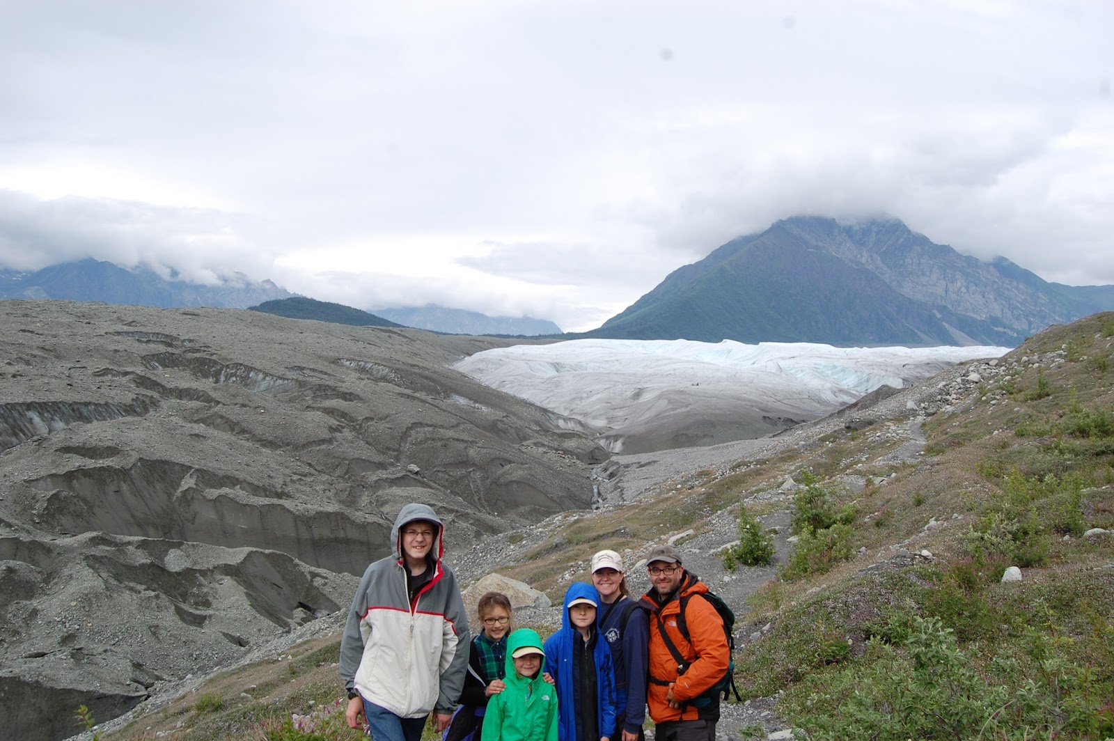
At the
end of the road we continued to hike another two miles to the toe of Root Glacier. The kids had a blast climbing around the
glacier, though it was a little slippery getting down since we were about the
only ones out there without crampons. The kids thought this was one of the best
parts of the trip. We made our way back
to Kennecott and took the shuttle back down to the river. Overall we hiked about six miles. We hit the road about 3:30pm and made the two
hour, 60 mile dirt road drive back to the main road. After that we drove another four hours to
Palmer. The drive from Glennallen to Palmer
was filled with awesome views of the Chugach Mountains.
 |
| Hiking out to Root Glacier |
 |
| Chugach Mountains outside of Palmer |
Wednesday, June 28: 3 hours drive time, 180 miles, 3198
miles total
We left Palmer and headed south toward Anchorage. Our first stop was Costco to get our tires rotated
and balanced and restock some of our food supplies. We then went over to REI to get our free
Alaska sticker. After that we had to
stop by the local Goodwill to pick up some cheap Alaska T-shirts. We then headed toward Turnagain Arm and then
south toward Seward.
 |
| Turnagain Arm outside of Anchorage |
By the time we got
to Seward the light rain started to increase, so most of the mountains that
surround Seward were barely visible. We
camped in a park right on Resurrection Bay.
There was a nice walking path between our camp and the marina and the
Kenai Fjords National Park Visitors Center.
The rain started coming again so we went back to camp for dinner and a
long rainy night in the tent.
 |
| Seward Harbor |
 |
| Camping right along Resurrection Bay, Seward |
Thursday, June 29: 3 hours drive time, 191 miles, 3389 miles
total
It was still raining pretty hard when we got up this
morning. There were several sea otters
floating around in the bay right off shore from where we were camping. After wringing out our shelter and tent we
drove over to Exit Glacier, which is part of Kenai Fjords National Park. Fortunately we arrived early enough to beat (most)
of the crowds. We hiked the 1.3 mile trail
up to the view point for the glacier.
Exit Glacier has been retreating quickly for the last several years, so
the view point at the end of the trail isn't as close to the glacier as it used
to be. The glacier is not very stable as
well, so you weren't allowed to get anywhere near it or climb on it.
 |
| Exit Glacier, Kenai Fjords National Park |
Once we got back to the parking lot we started
our drive across the Kenai Peninsula toward the very far end out to the city of
Homer. By the time we arrived in Homer
the rain had finally stopped. Homer is
famous for its spit, which sticks out for several miles out into Kachemak
Bay. We were going to camp right on the
beach, but the wind started to pick up, so we camped in a camping area a little
bit off of the beach, but still out on the spit. The kids loved being so close to the water
and explored up and down the beach.
 |
| Driving down to Homer |
After we got everything set up we decided to walk down to some of the
little shops and fish stores. Homer is
world famous for its fishing, especially halibut. We watched as people went about cleaning and
gutting all of the fish they hauled in that day. We ended up buying some Pacific cod and
Sockeye Salmon for dinner. We brought it
back and fried it up, along with some rice and mashed potatoes. The boys both loved the fish; the girls not so much. Even though it was already past 10 pm, we
went out to the beach to watch a sea otter and a seal that were floating along
the beach. With the sun not setting
until almost midnight, people were still out fishing until way past 11pm.
 |
| Out on Homer Spit |
 |
| Out on Homer Spit |
 |
| Pacific Cod and Sockeye Salmon for dinner (we didn't catch it) |
 |
| Fishing hole next to our campsite. This was taken well past 10pm at night. |
 |
| Sea Otter |
 |
| End of the Spit |
Friday, June 30: 5.5 hours drive time, 302 miles, 3691 miles
total
At first we thought about camping another night out on Homer
spit, but with the Fourth of July weekend arriving, we decided to get out of
town before the swarm of people arrived (some were already showing up by
noon). On our way out of town we stopped
at the Alaska Marine Wildlife Refuge Vistors Center. They had great displays on all the different
parts of the refuge, which covers most of the Aleutian Islands. We then hopped back into the car for the four
hour drive back to Anchorage. We stopped
at a couple of thrift stores and Costco again to get a few more items. Finally we made it to Camp LaDaSa, a church
camp our friends the Warnicks are running, which is just outside of Willow,
Alaska. Since another group had rented
the whole camp that night, we just pitched our tent out in the parking lot. The main/only rail line between Anchorage and
Fairbanks runs right next to the camp, so whenever the trains came by the whole
ground shook.
 |
| Camp LaDaSa with our friends the Warnicks |
Saturday, July 1: 2.5 hours drive time, 159 miles, 3850
miles total
This morning we finally did some of our laundry and took
showers. The group that was using the
camp was having a baptism service in the morning. Since the whole group was Tongan, most of the
service was in Tongan. It was pretty
neat to see the lady get baptized in the lake.
After she was baptized a bunch of people started singing in Tongan,
which was beautiful to hear. We then drove
back to Anchorage (which is only about an hour and 15 minutes away) and went to
the Anchorage weekend market. We looked
about at all of the vendors, but didn't find anything we couldn't live
without.
 |
| Anchorage Market |
After that we went over to the
Anchorage Zoo. The zoo isn't huge by any
means, but was different in that they specialized in animals from the north and
colder climates and orphaned animals.
The most recent additions were two black bear cubs that were orphaned. The zoo was taking care of them until they
will be sent off to a zoo in Southern California. By the end of the day the kids were pretty tired,
so we headed back toward the camp.
 |
| Musk Ox |
 |
| Baby Musk Ox |
 |
| Swan and duck fighting over space |
 |
| Brown bear |
 |
| Orphaned black bear cubs |
By
the time we got there our cabin had opened up and we were able to move into our
"home" for the next couple of days.
The Tongan group had done a pig roast the night before and gave us a
bunch of leftover pork. We heated it up
and ate it for dinner.
Sunday, July 2: no driving today!, 3850 miles total
It rained for most of the night. After breakfast we walked over to church,
which was just down a short trail from camp.
Their building was built in a log cabin type design, similar to the one
in Whitehorse (actually the one in Whitehorse was designed based on the Willow
building). After church a couple of families
that are camping in cabins next to us invited us over for a late brunch. They are all military families stationed in
Anchorage that are up here camping for the weekend. We took it easy for most of the day, since it
was raining hard all day. We went and
hung out with the Warnicks for a few hours and caught them up on all that was
happening back home. The military
families invited us for dinner as well.
This time they had a bunch of filipino food, since one of the ladies was
from the Philippines. They also had dutch
oven peach cobbler for dessert. So, needless
to say, we ate very well today.


 We continued driving through the Lamar Valley and
saw two moose in the distance. Once we
arrived in Cooke City it started to snow, and since it is the end of the road, we
decided to turn around and head back.
We continued driving through the Lamar Valley and
saw two moose in the distance. Once we
arrived in Cooke City it started to snow, and since it is the end of the road, we
decided to turn around and head back.